Rivers are the lifeblood of Assam — geographically, ecologically, and culturally. For aspirants preparing for APSC (Assam Public Service Commission), ADRE (Assam Direct Recruitment Examination), TET (Teacher Eligibility Test), DME (Directorate of Medical Education), and other state-level exams, the topic of major rivers of Assam is one of the most frequently tested areas in General Knowledge and Assam General Studies.

In this article, we will discuss everything you need to know: the origin, length, tributaries, significance, and exam-relevant facts about each major river of Assam — presented in a structured, easy-to-revise format.
Overview of Assam’s River System
Assam is one of the most river-rich states in India. It is drained primarily by two major river systems:
- The Brahmaputra River System (covering the Brahmaputra valley — the larger northern and central zone)
- The Barak River System (covering the Barak valley — the southern region of Assam including Cachar, Hailakandi, and Karimganj districts)
Key Fact for Exams: Assam has more than 50 rivers. The Brahmaputra, along with its numerous north-bank and south-bank tributaries, forms one of the largest river systems in Asia. The rivers originate from Tibet, Bhutan, Arunachal Pradesh, Nagaland, Manipur, and Meghalaya.
1. The Brahmaputra River — The Mighty Luit
Origin and Journey
The Brahmaputra originates from the Chemayungdung glacier near the Kailash Range in Tibet, at an altitude of approximately 5,300 metres above sea level. It is known by different names in different regions
| Region | Local Name | Country/State | Meaning |
| Tibet | Yarlung Tsangpo / Tsangpo | China (Tibet) | Purifier from heaven |
| Arunachal Pradesh | Siang / Dihang | India | — |
| Assam | Brahmaputra / Luit | India | Son of Brahma / Red River |
| Bangladesh | Jamuna | Bangladesh | — |
Key Facts about Brahmaputra
- Total length: approximately 2,900 km (one of the longest rivers in the world)
- Length within Assam: approximately 720 km
- It flows from east to west through Assam before turning south into Bangladesh
- The Brahmaputra is a trans-boundary river flowing through China, India, and Bangladesh
- It is the only major river in India that has a male name
- The river flows through the great Assam valley between the Himalayas to the north and the Shillong Plateau to the south
- Near Guwahati, the river narrows to about 1 km at Umanda Island (Peacock Island)
- Near Dibrugarh, the river can be as wide as 18 km during floods
Major Tributaries of the Brahmaputra in Assam
North Bank Tributaries (from Arunachal Pradesh & Bhutan)
- Subansiri River — largest north-bank tributary
- Jiabharali (Kameng / Jia Bhoreli)
- Manas River — flows through Manas Tiger Reserve
- Puthimari
- Pagladia
- Beki
- Champavati
- Saralbhanga
- Sankosh (forms Assam-West Bengal border)
- Dibang — joins near Sadiya
- Lohit — joins near Sadiya
South Bank Tributaries (from Meghalaya, Nagaland, Manipur Hills)
- Kopili River — major south-bank tributary; Kopili Hydel Project located here
- Digaru
- Kulsi
- Dhansiri (South) — flows from Nagaland
- Dihing / Dehing — Dibru-Saikhowa area
- Disang
- Doiyang
- Jhanji
- Bhogdoi — flows through Jorhat
Significance of Brahmaputra for Exams
- Majuli Island: world’s largest river island — located in the Brahmaputra; a major cultural and exam topic
- Kaziranga National Park lies on the south bank of Brahmaputra (Golaghat & Nagaon districts)
- The Brahmaputra carries one of the heaviest silt loads of any river in the world
- Saraighat Bridge (Guwahati) — first railway-cum-road bridge over Brahmaputra, opened 1963
- Kolia Bhomora Setu (Tezpur) and Naranarayan Setu (Jogighopa) are other important bridges
- Brahmaputra causes severe annual flooding in Assam — a major environmental and policy issue
2. The Barak River — Second Largest River System
Origin and Course
The Barak River originates from the Nagaland-Manipur border hills and flows westward through Manipur before entering Assam. It is the principal river of the Barak valley, covering the districts of Cachar, Hailakandi, and Karimganj.
- Total length: approximately 564 km
- Length in Assam: approximately 221 km
- Enters Assam at Jiribam (Manipur border area)
- At Bhanga (Bangladesh), it splits into two rivers: Surma and Kushiyara
- It ultimately drains into the Bay of Bengal via the Meghna River
Major Tributaries of Barak
- Sonai River
- Katakhal River
- Jiri River
- Singla River
- Longai River
- Madhura River
Exam Tip: Barak valley (Cachar region) is often called the ‘Surma Valley’ in older texts. The Barak river is the lifeline of the three districts in southern Assam.
3. Other Important Rivers of Assam (Tributaries in Detail)
Subansiri River
- Originates in Tibet; one of the major rivers of Arunachal Pradesh before entering Assam
- It is the largest north-bank tributary of Brahmaputra
- Length: approximately 442 km
- Flows through Subansiri district (Arunachal Pradesh) before entering Assam at Gerhelong
- The Lower Subansiri Hydroelectric Project (2,000 MW) is located here — a major exam topic
- Flows through Dhemaji and Lakhimpur districts in Assam
Manas River
- Originates in Bhutan (Royal Manas National Park area)
- Length: approximately 376 km
- Manas National Park — a UNESCO World Heritage Site and Project Tiger reserve in Assam
- It is a north-bank tributary of Brahmaputra, meeting it in Barpeta district
- Manas River forms the boundary between Assam and Bhutan in some stretches
Kopili River
- Originates in the Meghalaya hills (Jaintia Hills area)
- It is a major south-bank tributary of Brahmaputra
- Length: approximately 290 km
- Kopili Hydel Project (Umrangshu) — located in Karbi Anglong, generates hydroelectric power
- Flows through Karbi Anglong and Hojai (Nagaon) before joining Brahmaputra in Morigaon district
Dhansiri River
- Originates in the Nagaland hills
- Length: approximately 352 km
- Flows through Golaghat and Karbi Anglong districts
- A south-bank tributary of Brahmaputra
- Important for irrigation in the region
Dihing (Dehing) River
- Originates from the Patkai hills (Nagaland-Arunachal border)
- Passes through Dibru-Saikhowa National Park
- Dehing Patkai Wildlife Sanctuary lies along this river
- Joins Brahmaputra near Dibrugarh area
- Also known as the river of the Ahom heartland in historical texts
Jiabharali / Kameng River
- Known as ‘Kameng’ in Arunachal Pradesh
- Enters Assam as Jiabharali in Sonitpur district
- North-bank tributary of Brahmaputra
- Nameri National Park lies on the banks of Jiabharali
Dibang River
- Originates in Mishmi Hills of Arunachal Pradesh
- Joins Brahmaputra near Kobo (Lakhimpur district)
- One of the three rivers forming the ‘tri-junction’ near Sadiya (Dibang, Lohit, Siang)
- Dibang Valley district is named after this river
Lohit River
- Originates in Tibet (southeastern Tibetan plateau)
- Enters India through Arunachal Pradesh
- Joins Brahmaputra near Sadiya
- One of the key right-bank tributaries before the formation of main Brahmaputra stream
- Lohit district of Arunachal Pradesh is named after it
4. Quick Reference Table: Major Rivers of Assam
The following table is designed for rapid revision before exams:
| River | Origin | Enters Assam At | Length | Districts Covered | Drains Into |
| Brahmaputra | Tibet (Chemayungdung glacier) | Sadiya (enters Assam) | ~2,900 km (720 km in Assam) | Arunachal Pradesh, Assam | Bay of Bengal (via Bangladesh) |
| Barak | Manipur Hills (Nagaland-Manipur border) | Jiribam | ~564 km (221 km in Assam) | Manipur, Assam | Bay of Bengal (via Bangladesh) |
| Subansiri | Tibet | Gerhelong, Assam | ~442 km | Arunachal Pradesh, Assam | Brahmaputra (North bank) |
| Manas | Bhutan Himalayas | Barpeta district | ~376 km | Bhutan, Assam | Brahmaputra (North bank) |
| Kopili | Meghalaya Hills | Assam | ~290 km | Meghalaya, Assam | Brahmaputra (South bank) |
| Dihing (Dehing) | Patkai Hills | Upper Assam | ~287 km | Nagaland, Assam | Brahmaputra (South bank) |
| Dhansiri | Nagaland Hills | Golaghat district | ~352 km | Nagaland, Assam | Brahmaputra (South bank) |
| Jiabharali (Kameng) | Arunachal Pradesh | Sonitpur district | ~264 km | Arunachal Pradesh, Assam | Brahmaputra (North bank) |
| Jia Bhoreli | Bhutan | Sonitpur-Lakhimpur | ~120 km in Assam | Arunachal Pradesh, Assam | Brahmaputra (North bank) |
| Digaru | Meghalaya | Kamrup district | ~100 km | Meghalaya, Assam | Brahmaputra (South bank) |
| Kulsi | Meghalaya | Kamrup district | ~145 km | Meghalaya, Assam | Brahmaputra (South bank) |
| Sonai | Assam hills | Cachar district | ~80 km | Assam | Barak |
| Katakhal | Manipur Hills | Hailakandi | ~128 km | Manipur, Assam | Barak |
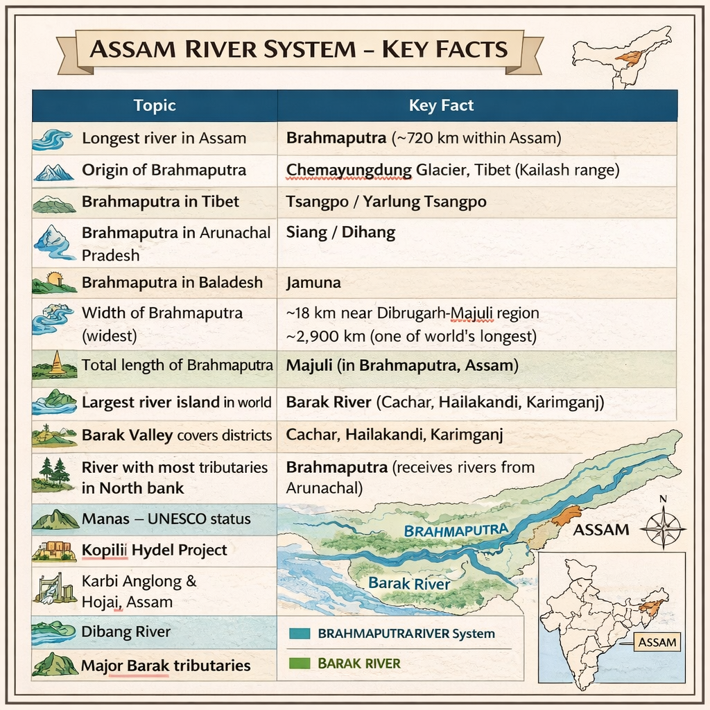
5. Important Facts & Exam Points at a Glance
| Topic | Key Fact |
| Longest river in Assam | Brahmaputra (~720 km within Assam) |
| Origin of Brahmaputra | Chemayungdung glacier, Tibet (Kailash range) |
| Brahmaputra in Tibet | Tsangpo / Yarlung Tsangpo |
| Brahmaputra in Arunachal Pradesh | Siang / Dihang |
| Brahmaputra in Bangladesh | Jamuna |
| Width of Brahmaputra (widest) | ~18 km near Dibrugarh-Majuli region |
| Total length of Brahmaputra | ~2,900 km (one of world’s longest) |
| Largest river island in world | Majuli (in Brahmaputra, Assam) |
| Second largest river system | Barak River (Cachar, Hailakandi, Karimganj) |
| River with most tributaries in N. bank | Brahmaputra (receives rivers from Arunachal) |
| Manas – UNESCO status | World Heritage Site and Tiger Reserve |
| Kopili Hydel Project | Karbi Anglong & Hojai, Assam |
| Dibang River | Joins Brahmaputra at Kobo, Assam |
| Lohit River | Joins near Sadiya; forms ‘Foot of Brahmaputra’ |
| Barak tributaries | Sonai, Katakhal, Jiri, Singla, Longai |

6. Rivers and Environment: Key Ecology Points
National Parks and Wildlife Sanctuaries Along Rivers
- Kaziranga National Park — South bank of Brahmaputra (Nagaon & Golaghat); home to the one-horned rhinoceros
- Manas National Park — On the Manas River (Barpeta district); UNESCO World Heritage Site
- Dibru-Saikhowa National Park — Brahmaputra and Lohit river confluence zone (Dibrugarh district)
- Nameri National Park — On Jiabharali River (Sonitpur district); important bird sanctuary
- Dehing Patkai Wildlife Sanctuary — Along Dehing River; called the ‘Amazon of the East’
- Pobitora Wildlife Sanctuary — South bank of Brahmaputra, Morigaon; second highest density of one-horned rhinos
Flooding — A Critical Environmental Issue
Assam experiences devastating floods almost every year, primarily due to the overflow of the Brahmaputra and its tributaries. The rivers carry heavy silt loads, causing riverbed elevation, which worsens flooding. This topic appears in APSC mains (General Studies), environment papers, and DME/TET contextual questions.
- Assam is one of the most flood-prone states in India
- Approximately 40% of Assam’s total land area is flood-prone
- The Brahmaputra carries one of the world’s highest sediment loads — about 800 million tonnes per year
- Majuli island is slowly shrinking due to erosion — a major ecology and current affairs topic
- NDRF (National Disaster Response Force) is regularly deployed during Assam floods
7. Hydroelectric & Irrigation Projects on Assam Rivers
| Project Name | River | District/Location | Significance |
| Kopili Hydel Project | Kopili | Karbi Anglong / Hojai | Oldest major hydel project in Assam |
| Lower Subansiri HEP (under construction) | Subansiri | Gerukamukh, Lakhimpur | 2,000 MW; one of India’s largest |
| Doyang Hydel Project | Doyang (Nagaland) | Nagaland (supplies Assam) | Supplies power to Assam grid |
| Ranganadi HEP | Ranganadi (tributary of Subansiri) | Arunachal Pradesh | 405 MW; power shared with Assam |
| Barak Multipurpose Project | Barak | Tipaimukh (Manipur border) | Proposed; controversial project |
8. Important Bridges Over Assam Rivers
Bridges are a frequently asked topic in APSC and ADRE exams under infrastructure and Assam GK:
- Saraighat Bridge (Guwahati) — first bridge over Brahmaputra; opened 1963; railway-cum-road
- Naranarayan Setu (Jogighopa) — second rail-road bridge; opened 1998
- Kolia Bhomora Setu (Tezpur) — road bridge over Brahmaputra; opened 1987
- Dhola-Sadiya Bridge (Bhupen Hazarika Setu) — longest bridge in India (9.15 km); over Lohit River; opened 2017
- Bogibeel Bridge (Dibrugarh) — India’s longest rail-road bridge (4.94 km) over Brahmaputra; opened 2018
- Basistha Bridge and Bharalumukh Bridge — important urban bridges in Guwahati over Brahmaputra
9. Historical and Cultural Significance of Rivers
Brahmaputra in Assamese Culture
The Brahmaputra — locally called ‘Luit’ or ‘Burlung Buthur’ (the ancient name) — holds a sacred place in Assamese culture. The river is addressed as a male deity unlike most Indian rivers. The famous folk song ‘Luitor Parey Parey’ by Bhupen Hazarika immortalized the river in Assamese music and identity.
- The river is worshipped as ‘Brah’ in some tribal traditions
- River ghats like Umananda ghat and Sukreswar ghat in Guwahati are important religious sites
- The Ahom kingdom drew its strength from the Brahmaputra’s resources for nearly 600 years
- Battle of Saraighat (1671) — fought between Ahoms and Mughals on the Brahmaputra near Guwahati; Ahom general Lachit Borphukan’s greatest victory
Majuli — The Floating Island
Majuli, the world’s largest inhabited river island, sits in the middle of the Brahmaputra in Jorhat district. It was granted district status in 2016. Majuli is the spiritual and cultural heart of Assam’s Vaishnavite tradition, with numerous Satras (monasteries) established by Srimanta Sankardev and his disciple Madhavdev.
- Area: approximately 880 sq km (though shrinking due to erosion)
- Jorhat district (Assam)
- Home to 22 functioning Satras
- Proposed UNESCO World Heritage Site
10. Practice MCQs — Major Rivers of Assam
These questions are based on the pattern of APSC Prelims, ADRE, TET, and DME examinations:
| Q. | Question | Answer |
| 1 | The Brahmaputra is known as _____ in Tibet. | Tsangpo |
| 2 | Which river is called the ‘Sorrow of Assam’? | No single river; flooding by Brahmaputra & tributaries causes sorrow (note: exam may say Brahmaputra) |
| 3 | The Brahmaputra enters India through which state? | Arunachal Pradesh |
| 4 | Which is the longest river flowing through Assam? | Brahmaputra |
| 5 | Manas River originates from which country? | Bhutan |
| 6 | Which river originates from the Chemayungdung glacier? | Brahmaputra (Tsangpo) |
| 7 | Which river divides Assam into the Brahmaputra and Barak valleys? | Barail Hills (not a river — it is the hill range separating them) |
| 8 | Kopili river flows on which bank of Brahmaputra? | South bank |
| 9 | Subansiri river flows on which bank of Brahmaputra? | North bank |
| 10 | Which river forms the boundary between Assam and Arunachal Pradesh at certain stretches? | Subansiri / Jiabharali |
| 11 | The Dibang and Lohit rivers join the Brahmaputra at which place? | Sadiya / Kobo area (Assam) |
| 12 | Kaziranga National Park lies on the banks of which river? | Brahmaputra |
| 13 | Which river flows through the Manas National Park and Wildlife Sanctuary? | Manas River |
| 14 | Which is the second largest river system in Assam? | Barak River |
| 15 | Which river is associated with the Kopili Hydel Project? | Kopili River |
11. Exam Strategy & Revision Tips
How Rivers Are Tested in APSC, ADRE, TET & DME
- APSC Prelims (CCE): 1–3 questions from Assam rivers per paper, typically in Assam GK and Geography sections
- ADRE Grade III & IV: 2–4 direct factual questions on rivers, tributaries, origins, and districts
- TET (Assam): Environmental Studies paper includes rivers and their importance for ecosystems
- DME (Medical recruitment): General Knowledge section may include 1–2 questions on rivers/geography
- SSC (Assam region): Rivers of northeast India, including Assam, are regularly tested
Top 5 Must-Know Points for Last-Minute Revision
- Brahmaputra = Tsangpo (Tibet) → Siang/Dihang (Arunachal) → Brahmaputra/Luit (Assam) → Jamuna (Bangladesh)
- Majuli = World’s largest river island = Brahmaputra river = Jorhat district = District since 2016
- Bogibeel Bridge = Longest rail-road bridge in India = 4.94 km = Brahmaputra = Dibrugarh = 2018
- Dhola-Sadiya Bridge = Longest bridge in India = 9.15 km = Lohit River = 2017 = named after Bhupen Hazarika
- Barak = second largest river system in Assam = Barak valley (Cachar, Hailakandi, Karimganj) = becomes Surma + Kushiyara in Bangladesh
Conclusion
Rivers define the geography, culture, economy, and ecology of Assam. Whether it is the majestic Brahmaputra shaping the landscape of the Brahmaputra valley, the Barak sustaining the people of southern Assam, or the smaller tributaries nurturing biodiversity and agriculture, a thorough knowledge of Assam’s rivers is indispensable for any exam aspirant.
Bookmark this study guide, revise the quick-reference table regularly, and attempt the MCQs to evaluate your preparedness. Combined with consistent practice, a strong grip over Assam’s river geography will significantly boost your score in APSC, ADRE, TET, DME, and all other Assam state recruitment examinations.
Disclaimer
The information provided in this article on Major Rivers of Assam is intended for general educational and informational purposes. While every effort has been made to ensure the accuracy and reliability of the facts related to the geography, river systems, and environmental aspects of Assam, the content should be used as a reference guide only. Readers are encouraged to verify specific details from official government publications, academic sources, or updated geographical records whenever necessary. The material is designed to support learning and general knowledge and should not be considered an official or authoritative document.
Source – River Atlas of Assam
Also Read
| S.No | Blog Title | Link |
|---|---|---|
| 1 | APSC Mains GS II Syllabus | Read Blog |
| 2 | APSC Mains GS III Syllabus | Read Blog |
| 3 | APSC Mains GS IV Syllabus | Read Blog |
| 4 | APSC Mains GS Paper V Syllabus | Read Blog |
| 5 | APSC Ethics Paper & Case Studies | Read Blog |
| 6 | APSC Toppers Writing Techniques | Read Blog |
FAQs on Major river system of Assam
How many major rivers of Assam are there?
The major rivers of Assam include the Brahmaputra, Barak, Subansiri, Manas, Dhansiri, Jia-Bharali, Kopili, and Beki. These rivers form the main river system and play a crucial role in the geography, agriculture, and ecosystem of Assam.
Which is the largest among the rivers of Assam?
The largest among the rivers of Assam is the Brahmaputra River. It flows across the state from east to west and is one of the widest and most powerful rivers in the world.
What are the two main river systems of the rivers of Assam?
The rivers of Assam are mainly divided into two river systems: the Brahmaputra River System and the Barak River System. These systems drain most parts of the state and support agriculture, transportation, and biodiversity.
Which rivers of Assam are important tributaries of the Brahmaputra?
Some important rivers of Assam that act as tributaries of the Brahmaputra include Subansiri, Manas, Jia-Bharali, Dhansiri, Beki, and Kopili. These tributaries contribute significantly to the water flow of the Brahmaputra basin.
Why are the rivers of Assam important for the state?
The rivers of Assam are important because they support agriculture, provide fertile soil through floods, enable transportation, and sustain rich biodiversity and ecosystems across the Brahmaputra and Barak valleys.