
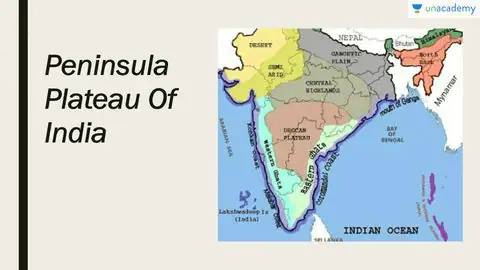
India’s topography is distinctly bisected by a slender and uneven belt that stretches from east to west, commonly recognized as the Peninsular Plateau. This geographical feature serves as a pivotal element in comprehending the diversity of India’s landscape. Within this expansive plateau, we encounter four primary geographic regions that contribute to India’s multifaceted terrain.
The Northern and Central Highlands form the northern part of the Peninsular Plateau. The Northern Highlands are characterized by the formidable Himalayan mountain range, which stands as India’s northern frontier and boasts the world’s highest peaks, including Mount Everest. In stark contrast, the Central Highlands are typified by undulating hills and plateaus, offering fertile grounds for agriculture and valuable mineral resources. This region has played a central role in India’s historical and cultural narrative, serving as a crucible for diverse traditions.
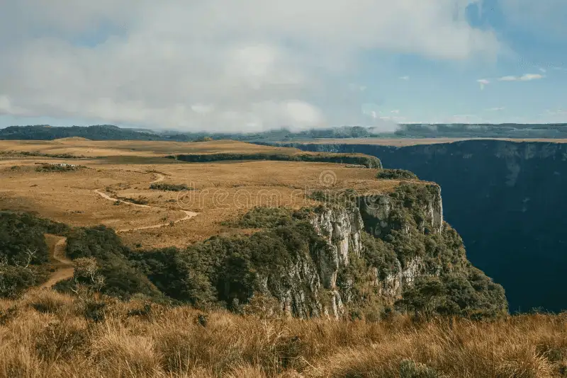
On the southern expanse of the Peninsular Plateau lies the Deccan Plateau, an extensive flat terrain marked by hills, cliffs, and meandering rivers. This region has been integral to India’s history, serving as a cradle of ancient Indian civilizations. Lastly, to the northeast of India, the Peninsular Plateau is referred to as the Northeastern Plateau, known for its verdant hills, luxuriant forests, and ample precipitation. The Brahmaputra River courses through this region, irrigating fertile plains and nurturing an array of flora and fauna. These four distinct geographic regions together compose the multifarious Peninsular Plateau of India, underlining the nation’s rich geographical tapestry and its profound influence on its history and culture.
READ MOREHow To Secure Rank 1 In APSC : Peninsular Plateau ( Important for APSC)
Definition of peninsular plateau
The Peninsular Plateau represents a flat expanse predominantly comprised of ancient crystalline, igneous, and metamorphic rock formations. Its genesis can be attributed to the fracturing and drifting of the Gondwana landmass, rendering it a component of one of Earth’s most ancient landmasses. This plateau showcases expansive, gently sloping valleys and hills with rounded contours. Within this plateau, one can discern two primary divisions: the Central Highlands and the Deccan Plateau.
Features of peninsular plateau
- The Peninsular Plateau has a rough triangular shape, with its base coinciding with the southern edge of North India’s great plain, and its apex is located at Kanniyakumari.
- It covers an extensive area of approximately 16 lakh square kilometers, constituting about half of India’s total land area, which is 32 lakh square kilometers.
- The plateau’s average elevation varies between 600 to 900 meters above sea level, with variations observed in different regions.
- Most of the rivers on the plateau flow from west to east, indicating a general slope in that direction. However, the Narmada and Tapti rivers are exceptions, flowing from east to west in rift zones caused by divergent boundaries.
- The Peninsular Plateau is one of the oldest landforms on Earth, composed primarily of Archaean gneisses and schists within its rock system.
- It has remained remarkably stable over geological time, with minimal structural changes since its formation.
- The plateau has largely remained above sea level for hundreds of millions of years, with only a few localized exceptions.
- The Peninsular Plateau is a complex landscape consisting of several smaller plateaus, hill ranges, river basins, and valleys, creating a diverse and dynamic geography.
Types of plateau
- Dissected plateau
- Volcanic plateau
Dissected plateau
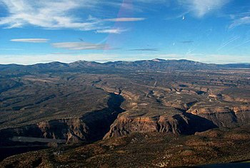
Dissected plateaus take shape through a rising motion within the Earth’s crust, a phenomenon primarily driven by the gradual collision of tectonic plates. One such illustration of a dissected plateau is the Colorado Plateau, often referred to as the stable Colorado Plateau or Colorado Plateau Province. This expansive region is characterized by its diverse landscape, encompassing arid grasslands, mountainous woodlands, and lush forests.
Volcanic plateau
As the name implies, volcanic plateaus are the result of numerous small volcanic eruptions. Over time, the gradual accumulation of lava from these eruptions forms a plateau known as a volcanic plateau. One noteworthy example of such a plateau is the North Island Volcanic Plateau, also referred to as the Waimarino Plateau, located in New Zealand. This region is distinguished by the presence of three active peaks: Mount Tongariro, Mount Ngauruhoe, and Mount Ruapehu, all contributing to the dynamic landscape of the volcanic plateau.
Plateaus are situated in the following geographical regions:
1. Mountainous areas
2. Desert regions
3. Beneath the ocean’s surface
The formation of plateaus
The formation of plateaus is a fascinating geological process, and it can be attributed to various underlying causes:
- Thermal Expansion
Some plateaus owe their existence to the phenomenon of thermal expansion within the Earth’s lithosphere. This occurs when the Earth’s crust and mantle heat up and expand, causing the land to rise and form plateaus. A prime example of this is the Yellowstone Plateau in the United States, which is renowned for its geothermal activity and unique geological features. Similarly, the Massif Central in France and the Ethiopian Plateau in Africa have also been shaped by thermal expansion processes over geological time.
- Crustal Shortening
Plateaus can also result from the geological process known as crustal shortening. This occurs when immense tectonic forces compress the Earth’s crust, causing one block of crust to thrust or overlap another. This can lead to the uplift of land, creating high plateaus. Notable plateaus formed by crustal shortening include those found in North Africa, Turkey, Iran, and Tibet. The Tibetan Plateau, for instance, is often referred to as the “Roof of the World” due to its immense elevation and the complex tectonic forces at play in the region.
- Volcanism
Another significant cause of plateau formation is volcanic activity, especially when vast amounts of lava are erupted and accumulate over time. This process results in the creation of volcanic plateaus. A prominent example is India’s Peninsular Plateau, which was formed by extensive volcanic activity and the eruption of flood basalts. The USA’s Columbia Plateau and the Canadian Shield are other examples of volcanic plateaus shaped by the accumulation of lava flows.
Each of these plateau formation mechanisms showcases the intricate geological processes that have shaped the Earth’s surface over millions of years, resulting in diverse and distinctive landscapes across the globe.
Minor plateaus in the peninsular plateau
The Marwar Plateau
The Marwar Plateau, also known as the Mewar Plateau, occupies the eastern region of Rajasthan, India. This plateau lies to the east of the Aravali mountain range, contrasting with the Marwar plain situated to the west of the Aravali Range. It is characterized by an average elevation ranging from 250 to 500 meters above sea level, with a gradual slope towards the east.
- Geological Composition
It is primarily composed of sandstone, shales, and limestones, all originating from the Vindhayan period.
- River Systems:
The Banas River, along with its tributaries such as the Berach and Khari rivers, originates in the Aravali Range and flows in a northwest direction into the Chambal River.
- Erosional Activity:
The erosional activity of these rivers has shaped the plateau’s topography, resulting in a landscape that resembles a rolling plain.
- Geological Significance:
The Marwar Plateau is a testament to the enduring geological processes that have played a role in shaping the diverse and unique landscapes of the Indian subcontinent over millions of years.
The Central Highland
The Central Highland also known as the Madhya Bharat Pathar or Madhya Bharat Plateau, is a prominent geographical feature situated east of the Marwar or Mewar Upland in India.
- Geographical Location
The Central Highland is a prominent plateau situated in the heart of India. It occupies a substantial portion of the country’s central region and is positioned to the east of the Marwar or Mewar Upland.
- Chambal River Basin
One of the defining features of the Central Highland is its association with the Chambal River basin. This extensive plateau largely comprises the basin of the Chambal River, which flows through a distinctive rift valley. The Chambal River is a lifeline for this region, nurturing the landscape and supporting the livelihoods of communities along its banks. Additionally, the plateau is crisscrossed by a network of rivers and streams, with the Kali Sindh, the Banas, the Parwan, and the Parbati as its primary tributaries. These watercourses bring life to the plateau’s otherwise arid terrain.
- Terrain and Flora
The Central Highland presents a picturesque terrain, characterized by gently rolling hills and undulating landscapes. The hills that define this region are predominantly composed of sandstone, contributing to the overall visual appeal of the plateau. A noteworthy feature of the Central Highland is its thick and verdant forests. These lush woodlands are home to a rich variety of flora and fauna, making it an ecologically significant area. The forests provide habitat for diverse wildlife and serve as a vital green lung in the heart of India.
- Ravines and Badlands
To the northern reaches of the Central Highland lie the distinctive ravines and badlands, which are synonymous with the Chambal River basin. These arid landforms, carved by the erosive forces of the Chambal River over centuries, create a unique and rugged landscape. The Chambal ravines not only add to the geological diversity of the region but also have cultural and historical significance.
The Central Highland is an integral part of India’s geographical mosaic, contributing to the country’s ecological and cultural diversity. Its alignment with the Chambal River, rich vegetation, and fascinating landforms make it a noteworthy region within the subcontinent, showcasing the wonders of nature and the complex interplay of geological forces over time.
Bundelkhand Upland:
The Bundelkhand Upland, defined by its specific boundaries and geological features, offers a fascinating glimpse into the dynamic processes that have shaped its distinctive landscape and character within the Indian subcontinent.
- Geographical Boundaries
The Bundelkhand Upland is delineated by specific geographic boundaries. It is situated to the north of the Yamuna River, bordered by the Madhya Bharat Pathar to the west, the Vindhyan Scarplands to the east and southeast, and the Malwa Plateau to the south.
- Geological Composition
This upland is primarily composed of the ‘Bundelkhand gneiss,’ an ancient and dissected upland featuring granite and gneiss rock formations.
- Regional Spread
The Bundelkhand Upland spans across five districts in the state of Uttar Pradesh and four districts in Madhya Pradesh, making it a significant geographical area.
- Elevation Profile
The average elevation in this upland varies from 300 to 600 meters above sea level. The terrain slopes downward from the Vindhyan Scarp towards the Yamuna River.
- Distinctive Features
The region is characterized by a series of hillocks composed mainly of granite and sandstone, contributing to its unique topography.
- Erosional Impact
Ongoing erosional processes by rivers, including the Betwa, Dhasan, and Ken, have transformed the upland into an undulating landscape. Consequently, it is not suitable for agricultural purposes.
- Senile Topography
The upland displays a senile topography, indicating its age in geological terms and the enduring influence of natural forces over time.
The Chotanagpur Plateau
The Chotanagpur Plateau is a diverse and geologically rich region known for its unique topography, drainage patterns, and valuable coal resources. Its varying elevations and geological features contribute to its significance within the Indian subcontinent.
- Geographic Extension
This plateau is primarily located in the state of Jharkhand, encompassing the northern part of Chhattisgarh and the Purulia district in West Bengal.
- River Systems
To the northwest of the plateau flows the Son River, which eventually joins the Ganga River, contributing to the region’s hydrology.
- Elevation Profile
The plateau’s average elevation stands at approximately 700 meters above sea level, rendering it a region of moderate elevation.
- Geological Composition
The Chotanagpur Plateau is predominantly composed of Gondwana rocks, showcasing its geological heritage.
- Drainage Pattern
It features a radial drainage pattern with numerous rivers and streams flowing in various directions. Key rivers such as the Damodar, Subarnrekaha, North Koel, South Koel, and Barkar have developed extensive drainage basins within the plateau.
- Damodar River
The Damodar River, flowing from west to east through a rift valley within the plateau, is of particular significance. This region hosts the Gondwana coal fields, a major source of coal production in India.
- Hazaribagh Plateau
North of the Damodar River lies the Hazaribagh Plateau, with an average elevation of about 600 meters above sea level. It features isolated hills and presents a peneplain-like appearance due to substantial erosion.
- Ranchi Plateau
South of the Damodar Valley, the Ranchi Plateau rises to an average elevation of 600 meters above sea level. It predominantly comprises rolling terrain and is home to the city of Ranchi, situated at 661 meters above sea level. The plateau also features monadnocks and conical hills at various locations.
- Rajmahal Hills
Forming the northeastern periphery of the Chotanagpur Plateau, the Rajmahal Hills are primarily composed of basalt and are covered by lava flows. These hills, oriented in a north-south direction, boast an average elevation of around 400 meters, with the highest peak reaching 567 meters. The region has experienced extensive erosion, resulting in the formation of separate plateaus.
The Meghalaya Plateau
The Meghalaya Plateau an extension of the peninsular plateau, stretches eastward beyond the Rajmahal Hills, forming a distinct geographical feature known as Meghalaya or the Shillong Plateau.
- Geographic Boundary
This plateau is separated from the primary landmass by the Garo-Rajmahal Gap. This gap was formed through a geological process called down-faulting, where a block of the Earth’s crust slides downwards. Subsequently, it was filled with sediments carried by the Ganga and Brahmaputra rivers over time.
- Geological Composition
Comprising the Meghalaya Plateau are ancient Archaean rocks, including quartzites, shales, and schists, offering insights into the region’s geological history.
- Sloping Terrain
The plateau gradually slopes down towards the Brahmaputra Valley in the north and the Surma and Meghna Valleys in the south, contributing to its diverse topography.
- Western Boundary
Its western boundary closely aligns with the border of Bangladesh, delineating its extent in that direction.
- Distinctive Hills
The Meghalaya Plateau is further distinguished by its various hill ranges. These include the Garo Hills, with elevations around 900 meters, the Khasi-Jaintia Hills towering at approximately 1,500 meters, and the Mikir Hills, characterized by heights of around 700 meters. Notably, the plateau’s highest point is Shillong, situated at an elevation of 1,961 meters.
The Meghalaya Plateau is a remarkable geographical entity with a rich geological heritage and a variety of elevations and landscapes, making it a notable feature within the Indian subcontinent.
Deccan Plateau
The Deccan Plateau, with its vast expanse and diverse landscapes, holds a prominent place in India’s geographical makeup.
- Geographical Extent
The Deccan Plateau spans an expansive area of approximately five lakh square kilometers.
- Shape and Boundaries
It is characterized by a triangular shape and is geographically bounded by the Satpura and Vindhya Ranges to the northwest, the Mahadev and Maikal Ranges to the north, the Western Ghats to the west, and the Eastern Ghats to the east.
- Elevation Profile
On average, the plateau stands at an elevation of 600 meters above sea level. However, it reaches higher elevations of up to 1000 meters in the southern regions and gradually descends to 500 meters in the north.
- Slope and Drainage
The plateau exhibits a general west-to-east slope, which is evident from the flow of its major rivers. These rivers have played a significant role in subdividing the plateau into several smaller plateaus and regions.
The Maharashtra Plateau
The Maharashtra Plateau, situated within the state of Maharashtra, constitutes the northern segment of the expansive Deccan Plateau. The Maharashtra Plateau, with its unique geological composition and diverse landforms, holds significance in the Deccan Plateau region and plays a crucial role in agriculture and natural heritage.
- Geographical Location
This plateau region is primarily located in the state of Maharashtra, India.
- Geological Composition
Much of the Maharashtra Plateau is underlain by basaltic rocks of volcanic origin, and it includes a substantial portion of the Deccan Traps, a prominent volcanic province in the Indian subcontinent.
- Topographical Appearance
The Maharashtra Plateau presents a landscape that resembles a rolling plain, primarily due to the effects of weathering over time.
- Deccan Trap Topography
The plateau’s distinctive topography is characterized by horizontal lava sheets, giving rise to the classic Deccan Trap formation, marked by step-like features.
- River Valleys
Broad and shallow valleys, notably those of the Godavari, Bhima, and Krishna rivers, are flanked by flat-topped, steep-sided hills and ridges, contributing to the region’s varied terrain.
- Soil Type
The entire expanse of the Maharashtra Plateau is covered by a type of fertile soil known as black cotton soil, or regur, which is highly conducive to agricultural activities.
The Karnataka Plateau
The Karnataka Plateau alternatively known as the Mysore Plateau, is a significant geographical region located to the south of the Maharashtra Plateau. The Karnataka Plateau, with its distinctive features, elevations, and regional divisions, is a noteworthy component of the Deccan Plateau, contributing to the rich geographical tapestry of southern India.
- Alternative Name
Referred to as the Mysore Plateau, the Karnataka Plateau is an integral part of the southern Deccan Plateau.
- Topographic Features
This plateau presents a distinctive landscape characterized by a rolling plateau terrain, with an average elevation ranging from 600 to 900 meters above sea level.
- River Network
The plateau’s topography is intricately dissected by a network of rivers originating from the Western Ghats, which lies to the west. These rivers have played a significant role in shaping the plateau’s landscape.
- Hill Trends
The general trend of the hills within the Karnataka Plateau is either parallel to the Western Ghats or perpendicular to them, contributing to the region’s diverse topography.
- Highest Peak
The plateau features notable elevations, with the highest peak, Mulangiri, reaching 1913 meters. This peak is situated in the Baba Budan Hills within the Chikmagalur district.
- Division into Two Parts
The Karnataka Plateau can be divided into two distinct regions:
- Malnad :This term in Kannada translates to “hill country.” It comprises deep valleys covered with dense forests, creating a lush and scenic landscape.
- Maidan: In contrast, the Maidan region is characterized by rolling plains interspersed with low granite hills, offering a different facet of the plateau’s topography.
- Transition to Nilgiri Hills
Towards its southern reaches, the Karnataka Plateau tapers off between the Western Ghats and the Eastern Ghats, ultimately merging with the Nilgiri Hills. This transition adds to the plateau’s overall geographical diversity.
The Telangana Plateau
The Telangana Plateau, characterized by its geological composition, elevation variations, and river systems, holds a prominent place within the Deccan Plateau’s diverse landscapes.
- Geological Composition
This plateau is predominantly comprised of Archaean gneisses, reflecting its ancient geological heritage.
- Average Elevation
The average elevation of the Telangana Plateau ranges between 500 to 600 meters above sea level, contributing to its moderate elevation profile.
- Elevation Variation
The southern part of the plateau boasts higher elevations compared to its northern counterpart, introducing topographic diversity.
- River Drainage
The region is traversed by three significant river systems: the Godavari, the Krishna, and the Penneru, each playing a crucial role in shaping the plateau’s hydrology.
- Geological Features
The plateau’s topography exhibits a division between Ghats and Peneplains. The term “Peneplains” refers to vast, featureless, undulating plains formed during the final stages of deposition processes.
The Chhattisgarh Plain
The Chhattisgarh Plain, renowned for its geographical attributes and historical significance, remains a distinctive feature within the Peninsular plateau.
- Geographic Significance
This plain stands out as the primary and noteworthy plain in the Peninsular plateau.
- Topographic Configuration
The Chhattisgarh Plain assumes a saucer-shaped depression, with its drainage primarily directed towards the upper reaches of the Mahanadi River.
- Geographic Boundaries
The entirety of this basin is enclosed by the Maikala Range to the west and the Odisha hills to the east.
- Historical Heritage
Historically, the region was under the rule of the Haithaivanshi Rajputs, who left their mark through a network of thirty-six forts (Chhattisgarh), which subsequently lent the region its name.
- Geological Composition
The basin is characterized by nearly horizontal layers of limestone and shales, forming a significant part of its geological makeup.
- Elevation Profile
The general elevation of the Chhattisgarh Plain exhibits a gradual rise from approximately 250 meters in the east to around 330 meters in the west.
The Indian Peninsular Plateau
The Indian Peninsular Plateau, with its ancient rock formations and distinct topographical features, holds a pivotal place in India’s geography and geological heritage.
- The Indian Peninsular Plateau characterized by its unique geological composition, is primarily composed of ancient crystalline, igneous, and metamorphic rocks. Its formation is closely linked to the geological processes that led to the breakup of the Gondwana landmass. Notable features of the Indian Peninsular Plateau include:
- The plateau exhibits a diverse topography, featuring broad and shallow valleys along with rounded hills, contributing to its distinctive landscape.
- The Indian Peninsular Plateau is broadly divided into two significant divisions: the Central Highlands of India and the Deccan Plateau.
- Within the Deccan Plateau, the presence of the Western Ghats and Eastern Ghats adds to the plateau’s geographical diversity, influencing its terrain and climate.
A noteworthy part of the plateau, known as the Deccan Trap, is characterized by volcanic origins and the presence of igneous rocks, offering insights into the region’s geological history.
1. What is the Peninsular Plateau?
The Peninsular Plateau is a vast, elevated landmass located in the southern part of India. It is a tableland composed of ancient crystalline, igneous, and metamorphic rocks.
2. What are the major divisions of the Peninsular Plateau?
The Peninsular Plateau is divided into two main divisions: the Central Highlands of India and the Deccan Plateau.
3. What are the key geographical features of the Peninsular Plateau?
The plateau is known for its broad and shallow valleys, rounded hills, and distinct mountain ranges such as the Western Ghats and Eastern Ghats.
4. What is the significance of the Western Ghats and Eastern Ghats within the Peninsular Plateau?
The Western Ghats and Eastern Ghats are prominent mountain ranges that influence the climate, drainage patterns, and biodiversity of the plateau. They also act as a barrier to the monsoon winds.
5. How was the Peninsular Plateau formed geologically?
The formation of the Peninsular Plateau is associated with the breaking apart of the ancient Gondwana landmass, leading to the uplift of the plateau’s rocks over millions of years.