Introduction
An earthquake is a sudden shaking of the Earth’s surface. It happens when energy stored inside the Earth’s outer layer (called the lithosphere) is suddenly released. This release of energy creates waves called seismic waves, which make the ground shake. Earthquakes can cause damage to buildings, roads, and even change the shape of the land.
Studying earthquakes helps us understand how and why they happen. This knowledge is important for subjects like Geography (GS Paper 1) and for making better plans to reduce damage and keep people safe during disasters, which is important in Disaster Management (GS Paper 3).
Why does the Earth shake?
- The Earth shakes because energy is released deep underground. This happens along a crack in the Earth’s crust called a fault. Energy is released along faults, which are sharp fractures in the Earth’s crust.
- Over time, the pressure builds up until it becomes too strong. Along these faults, rocks tend to move in opposite directions. This sudden movement releases a lot of energy. The energy spreads out in the form of waves, which travel in all directions and shake the ground.
- The place inside the Earth where this energy is released is called the focus (or hypocenter). The point on the ground directly above the focus is called the epicenter. It is the first place on the surface to feel the shaking.
Causes of Earthquakes
Earthquakes can be triggered by various natural and anthropogenic factors:
1. Tectonic Plate Movements
- Tectonic earthquakes are the most frequently occurring type. Although the Earth appears solid from the surface, its interior is highly dynamic. It comprises four primary layers: the solid crust, nearly solid mantle, liquid outer core, and solid inner core.
- Tectonic plates (also called lithospheric plates) are constantly moving atop the slowly flowing mantle layer beneath. This continuous movement causes stress within the Earth’s crust. When the pressure becomes too much, it causes cracks in the Earth’s crust. These cracks are called faults
- The movement of tectonic plates at convergent, divergent, or transform boundaries causes slippage along these faults, leading to earthquakes.
2. Volcanic Activity
- Volcanic earthquakes happen in areas where there are active volcanoes. They are a special type of tectonic earthquake.
- These earthquakes are caused when hot, melted rock called magma moves underground. When magma is pushed into or pulled out of spaces inside the Earth, it creates pressure. This pressure can crack the rocks, shake the ground, and sometimes even cause the land to sink or large cracks to form.
- Even though volcanic earthquakes don’t always mean a volcano will erupt soon, they can happen at any time in areas with volcanoes.
3. Human-Induced Seismicity
Sometimes, human activities can also cause earthquakes. These are called man-made or human-induced earthquakes. Here are some examples:
- Mining Activities: When people dig deep into the Earth to mine minerals, it can change the pressure underground. This can lead to small collapses or earthquakes.
- Big Dams and Reservoirs: When large amounts of water are stored behind dams, the weight of the water puts pressure on the ground below. This can cause the rocks to move and trigger earthquakes. This is called reservoir-induced seismicity.
- Fracking (Hydraulic Fracturing): In some places, people pump liquids into the ground to take out oil or gas. This process can cause the rocks to crack and sometimes results in small earthquakes.
Hypocenter and Epicenter :
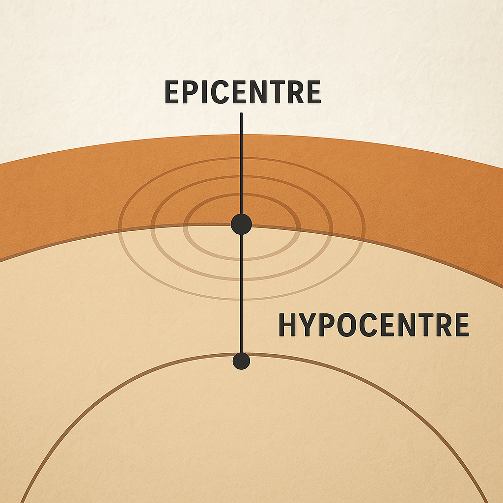
Understanding the origin points of an earthquake is vital:
- Hypocenter (Focus): This is the exact point inside the Earth where the earthquake starts. It’s where the rocks break and energy is released.
- Epicenter: This is the point on the Earth’s surface, directly above the focus. It is the first place to feel the shaking.
When the focus is shallow (closer to the surface), the shaking is usually stronger and causes more damage.
Types of Seismic Waves
When an earthquake occurs, it produces seismic waves that travel through the Earth. These waves are divided into two main types:
1. Body Waves
These waves travel through the inside of the Earth.
- Primary Waves (P-Waves):
- These are the fastest seismic waves.
- They move in a straight line by pushing and pulling the ground.
- They can travel through solids, liquids, and gases.
- These are the fastest seismic waves.
- Secondary Waves (S-Waves):
- These are slower than P-waves.
- They move the ground side to side or up and down.
- They can only travel through solids, not liquids or gases.
- These are slower than P-waves.
2. Surface Waves
These waves move along the surface of the Earth and usually cause more damage than body waves.
- Love Waves:
- They cause the ground to move side to side in a horizontal direction.
- They cause the ground to move side to side in a horizontal direction.
- Rayleigh Waves:
- They create a rolling motion, moving the ground both up and down and side to side, similar to waves in the ocean.
Measuring Earthquakes
Earthquakes are quantified by their magnitude and intensity:
1. Magnitude
- Richter Scale: Developed in 1935 by Charles F. Richter, it measures the amplitude of seismic waves. It’s logarithmic, meaning each whole number increase represents a tenfold increase in measured amplitude.
- Moment Magnitude Scale (Mw): Provides a more accurate measure of an earthquake’s size by considering the area of the fault that slipped, the amount of slip, and the force required to overcome friction.
2. Intensity
- Modified Mercalli Intensity Scale (MMI): Assesses the effects of an earthquake at different locations, considering observations of ground shaking and damage. It ranges from I (not felt) to XII (total destruction).
Distribution of Earthquakes
Although earthquakes can occur anywhere and at any time, historical patterns reveal that they tend to concentrate in specific zones across the globe, recurring in these regions year after year. Primarily, earthquakes are distributed across three major seismic belts of the Earth:
1. Circum-Pacific Seismic Belt (Ring of Fire):
- This is the world’s most significant earthquake belt, encircling the Pacific Ocean.
- Approximately 81% of the planet’s largest earthquakes occur within this zone, which is commonly referred to as the “Ring of Fire.”
- This seismic belt lies along the boundaries of tectonic plates, where plates—predominantly composed of oceanic crust—are subducting or sinking beneath other plates.
- Earthquakes in these regions are caused by slip movements between plates and ruptures within the plates themselves.
2. Alpide Earthquake Belt (Mid-Continental Belt):
- The Alpide belt stretches from Java to Sumatra, passing through the Himalayas and the Mediterranean region, and extends into the Atlantic Ocean.
- It contributes to roughly 17% of the world’s largest earthquakes, including some of the most devastating in human history.
3. Mid-Atlantic Ridge Seismic Belt:
- The third major earthquake belt is aligned along the submerged Mid-Atlantic Ridge, a region where two tectonic plates are diverging—moving away from each other—marking a divergent plate boundary.
- Most of this ridge lies deep beneath the ocean and is distant from human habitation, making its seismic activity less threatening to human life and infrastructure.
Seismic Zones in India
India is divided into four seismic zones based on earthquake risk:
| Zone | Description | Regions Included |
| Zone II | Low seismic risk | Remaining areas of Rajasthan, Haryana, Madhya Pradesh, Maharashtra, Odisha, Andhra Pradesh, Telangana, Karnataka, and Tamil Nadu |
| Zone III | Moderate seismic risk | Kerala, Goa, Lakshadweep, parts of Uttar Pradesh, Haryana, Gujarat, Punjab, West Bengal, western Rajasthan, Madhya Pradesh, Bihar, northern Jharkhand and Chhattisgarh, Maharashtra, Odisha, Andhra Pradesh, Telangana, Tamil Nadu, and Karnataka |
| Zone IV | High seismic risk | Remaining parts of J&K and Ladakh, remaining areas of Himachal Pradesh and Uttarakhand, parts of Haryana and Punjab, Delhi, Sikkim, northern Uttar Pradesh, small regions of Bihar and West Bengal, parts of Gujarat, western coastal Maharashtra, and western Rajasthan |
| Zone V | Very high seismic risk | Kashmir Valley (Jammu & Kashmir), western Himachal Pradesh, eastern Uttarakhand, Rann of Kutch (Gujarat), northern Bihar, entire Northeast India, Andaman & Nicobar Islands |
Major Earthquakes in India
India has experienced several significant earthquakes:
- 1934 Bihar-Nepal Earthquake: Magnitude 8.0; caused extensive damage in northern Bihar and Nepal.
- 1950 Assam Earthquake: Magnitude 8.6. One of the most powerful earthquakes in Indian history, it struck Assam and parts of Tibet, resulting in landslides, floods, and heavy casualties.
- 1993 Latur Earthquake (Maharashtra):
- Magnitude 6.3. Struck the Latur and Osmanabad regions, leading to the death of nearly 10,000 people. It was unusual as it occurred in a stable continental region, which was previously considered low-risk for earthquakes.
- 1991 Uttarkashi Earthquake (Uttarakhand): Magnitude 6.6. Struck the Garhwal Himalayas, especially affecting the Uttarkashi region. Over 1,000 people lost their lives, and numerous homes and temples were destroyed. Landslides blocked roads and hampered rescue efforts.
- 1993 Latur Earthquake (Maharashtra):
- Magnitude 6.3. Struck the Latur and Osmanabad regions, leading to the death of nearly 10,000 people. It was unusual as it occurred in a stable continental region, which was previously considered low-risk for earthquakes.
- 2001 Bhuj Earthquake (Gujarat): Magnitude 7.7. Occurred on 26th January (Republic Day), causing catastrophic damage in the Kutch district. Over 20,000 lives were lost, and thousands of buildings, including hospitals and schools, collapsed. Entire villages were wiped out.
Effects of Earthquake
Earthquakes are considered a major natural hazard, capable of causing widespread destruction depending on their intensity and location. High-magnitude tremors can result in significant loss of life and property. The immediate and hazardous consequences of an earthquake include the following:
- Ground Shaking: The most noticeable and direct effect, where the earth’s surface vibrates due to seismic waves, often leading to structural damage.
- Differential Ground Settlement: Uneven settling of the ground, which can damage buildings, roads, and underground utilities.
- Land and Mudslides: In hilly or mountainous regions, earthquakes can trigger landslides and mudflows, burying settlements and cutting off transportation routes.
- Fires: Earthquakes may rupture gas lines, electrical cables, and fuel containers, leading to widespread fires.
- Ground Lurching: Irregular movement of the ground that can distort foundations and damage roads and pipelines.
- Avalanches: In snow-covered regions, earthquakes can dislodge large volumes of snow, causing avalanches.
- Ground Displacement: Permanent displacement of the earth’s surface can occur, leading to damage in transportation and communication networks.
- Floods from Dam and Levee Failures: Strong tremors can damage dams and levees, resulting in catastrophic flooding of downstream areas.
- Structural Collapse: Buildings, bridges, and other infrastructures may collapse, causing heavy casualties and disrupting services.
- Tsunami: Undersea earthquakes can displace massive volumes of water, generating tsunamis that affect coastal areas far from the epicenter.
Mitigation Strategies for Earthquakes
Earthquake mitigation involves measures to reduce damage and loss of life during seismic events. These strategies are applied at individual, community, and governmental levels.
Key Strategies
- Building Codes: Adoption of earthquake-resistant design standards to ensure structural safety.
- Land Use Planning: Avoiding construction in high-risk zones through proper zoning and planning.
- Public Awareness: Educating citizens on safety protocols during earthquakes.
- Disaster Preparedness: Emergency plans, drills, and supply stocking to improve readiness.
- Risk Assessment: Identifying high-risk cities to prioritize mitigation efforts and response strategies.
India’s Preparedness Measures
- National Centre for Seismology: Monitors earthquakes via 115 observatories and disseminates real-time alerts to disaster authorities.
- National Earthquake Risk Mitigation Project (NERMP): Centrally sponsored scheme targeting seismic zones IV & V with a focus on techno-legal measures and institutional capacity.
- Seismic Microzonation: Mapping of urban seismic risk to guide safer building practices in cities with over 5 lakh population.
- NDMA Awareness Campaigns: Annual campaigns through multiple media channels to promote earthquake safety and preparedness.
- Building Code Guidelines: Issued by BIS, BMTPC, and HUDCO to ensure structures in vulnerable zones are earthquake-resilient.
- Earthquake Disaster Risk Index: NDMA’s tool to assess vulnerability and guide city-specific disaster risk reduction plans.
Challenges in India
- High Seismic Vulnerability: India’s location along the Indian-Eurasian plate makes it prone to frequent earthquakes.
- Unplanned Urbanization: Rapid construction without seismic compliance increases vulnerability.
- Regulatory Lapses: Weak enforcement of building codes; e.g., ~80% of Delhi’s buildings violate norms.
- Tourism in Risk Zones: Increased footfall in seismic-prone regions raises risk during disasters.
- Limited Public Awareness: Lack of public knowledge on safety measures hampers community resilience.
- Funding Gaps: Insufficient financial resources for retrofitting, research, and preparedness.
Way Forward
- Strengthen enforcement of building codes and retrofitting mandates.
- Integrate earthquake safety into urban planning and infrastructure development.
- Enhance public education and community preparedness.
- Increase budgetary allocation for disaster resilience and early warning systems.
UPSC MAINS PYQ –
Q. Discuss the vulnerability of India to earthquake-related hazards. Give examples including the salient features of major disasters caused by earthquakes in different parts of India during the last three decades. [150 words, 10 Marks]
Q. The frequency of earthquakes appears to have increased in the Indian subcontinent. However, India’s preparedness for mitigating their impact has significant gaps. Discuss various aspects. (UPSC Mains 2015).